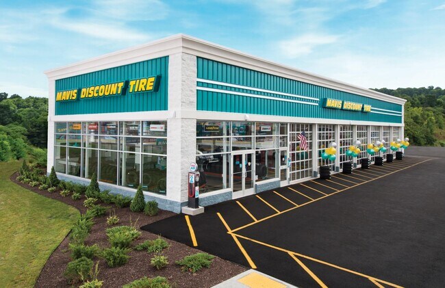
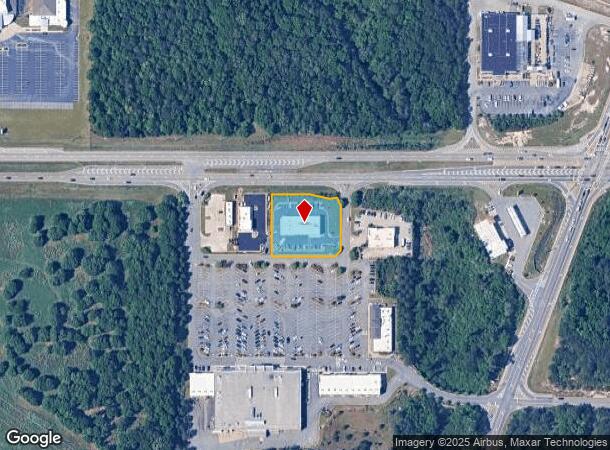
Property Record
6019 Watson Blvd, Warner Robins, GA 31093
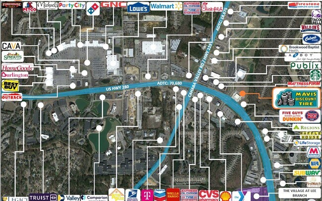
NEARBY LISTINGS FOR SALE OR LEASE
Property Detail
6019 Watson Blvd
Warner Robins, GA
Watson Ho Lk 8.00 Sf
0W78L0053000
LOT 2 1.043 ACRES 69/5TH
Autorepair
Houston
X
Georgia
13225C0130C
2
2024
1.04 AC
2024
Perry/Warner Robins
020111
Other Market Areas
5,520 SF
DEMOGRAPHICS near 6019 Watson Blvd
1 Mile
3 Mile
5 Mile
2024 Total Population
4,345
33,914
90,525
2029 Population
4,716
36,938
98,357
Pop Growth 2024-2029
+ 8.54%
+ 8.92%
+ 8.65%
Average Age
37
39
39
2024 Total Households
1,840
13,546
35,479
HH Growth 2024-2029
+ 8.48%
+ 8.70%
+ 8.50%
Median Household Inc
$63,301
$69,579
$71,754
Avg Household Size
2.30
2.50
2.50
2024 Avg HH Vehicles
2.00
2.00
2.00
Median Home Value
$159,265
$165,268
$163,395
Median Year Built
2001
1997
1993
Nearby Places
Map Layers
Map Styles
 Street
 Aerial
- Restaurants
- Banks
- Shops
- Fitness
- Groceries
SALE & LEASE HISTORY
LISTING DATE
SALE/LEASE

Jan 23, 2023
For Sale
Nearby Properties
Address
Land Use
TOTAL SIZE
Lot Size
Zoning
Address
Land Use
TOTAL SIZE
Lot Size
Zoning
27,504 SF
26.31 AC
PUD
Address
Land Use
TOTAL SIZE
Lot Size
Zoning
9,600 SF
24.25 AC
C-H
Address
Land Use
TOTAL SIZE
Lot Size
Zoning
68,545 SF
19.94 AC
MULTI
Address
Land Use
TOTAL SIZE
Lot Size
Zoning
5,648 SF
49.72 AC
R4
Address
Land Use
TOTAL SIZE
Lot Size
Zoning
14,754 SF
24 AC
C2
Address
Land Use
TOTAL SIZE
Lot Size
Zoning
15,006 SF
28 AC
PDE
Address
Land Use
TOTAL SIZE
Lot Size
Zoning
7,172 SF
24.73 AC
R4
Address
Land Use
TOTAL SIZE
Lot Size
Zoning
226,032 SF
49.90 AC
C2
Address
Land Use
TOTAL SIZE
Lot Size
Zoning
11,056 SF
17.41 AC
R4
Address
Land Use
TOTAL SIZE
Lot Size
Zoning
301,206 SF
19.79 AC
C2
Address
Land Use
TOTAL SIZE
Lot Size
Zoning
338,708 SF
28.28 AC
M-2
Address
Land Use
TOTAL SIZE
Lot Size
Zoning
18,954 SF
20 AC
C2
Address
Land Use
TOTAL SIZE
Lot Size
Zoning
92,930 SF
18.66 AC
C2
Address
Land Use
TOTAL SIZE
Lot Size
Zoning
158,300 SF
29.99 AC
R1
Address
Land Use
TOTAL SIZE
Lot Size
Zoning
21,750 SF
11.48 AC
C2
Address
Land Use
TOTAL SIZE
Lot Size
Zoning
63,274 SF
40.80 AC
C-2, WR
Address
Land Use
TOTAL SIZE
Lot Size
Zoning
223,608 SF
22.40 AC
C2
Address
Land Use
TOTAL SIZE
Lot Size
Zoning
56,260 SF
17.70 AC
C2
Address
Land Use
TOTAL SIZE
Lot Size
Zoning
5,320 SF
15.47 AC
R-4
Address
Land Use
TOTAL SIZE
Lot Size
Zoning
15,184 SF
14.03 AC
R4
Address
Land Use
TOTAL SIZE
Lot Size
Zoning
100,500 SF
19.64 AC
R2
Address
Land Use
TOTAL SIZE
Lot Size
Zoning
60,300 SF
6.99 AC
M-2, WR
Address
Land Use
TOTAL SIZE
Lot Size
Zoning
100,500 SF
19.74 AC
R2
Address
Land Use
TOTAL SIZE
Lot Size
Zoning
100,000 SF
19.66 AC
R1
Address
Land Use
TOTAL SIZE
Lot Size
Zoning
132,851 SF
24.05 AC
C2
Address
Land Use
TOTAL SIZE
Lot Size
Zoning
125,797 SF
5.74 AC
M2
Address
Land Use
TOTAL SIZE
Lot Size
Zoning
125,412 SF
9.82 AC
C2
Address
Land Use
TOTAL SIZE
Lot Size
Zoning
84,909 SF
8.64 AC
C2
Address
Land Use
TOTAL SIZE
Lot Size
Zoning
70,500 SF
18.47 AC
R1
Address
Land Use
TOTAL SIZE
Lot Size
Zoning
14,140 SF
16.59 AC
R1
The World's #1 Commercial Real Estate Marketplace
Connect with us
© 2025 CoStar Group
The information above has been obtained from sources believed reliable. While we do not doubt its accuracy we have not verified it and make no guarantee, warranty or representation about it. It is your responsibility to independently confirm its accuracy and completeness. Any projections, opinions, assumptions, or estimates used are for example only and do not represent the current or future performance of the property. The value of this transaction to you depends on tax and other factors which should be evaluated by your tax, financial, and legal advisors. You and your advisors should conduct a careful, independent investigation of the property to determine to your satisfaction the suitability of the property for your needs.